Stage 10 Ennezat - Le Mont-Dore Puy de Sancy (165.3km)
Festive stage promises fireworks on multiple fronts on volcanic terrain
On Monday, the Tour de France doesn't count a rest day, while that is traditionally the case. That has everything to do with the French national holiday Quatorze Juillet. The French must 'naturally' be able to watch cycling. Organizer ASO has therefore drawn up a beautiful course in the Auvergne.
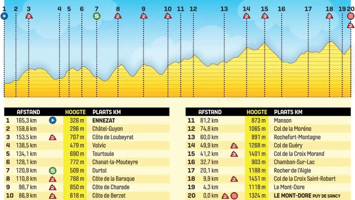
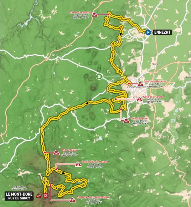
The stage counts 163 kilometers on Monday and more than 4,300 meters of elevation gain with seven steep climbs. The riders start Monday in Ennezat and begin almost immediately with the Côte de Loubeyrat, a test of 4 kilometers with an average gradient of 6.3%. There, an early breakaway immediately gets the chance to ride away from the peloton. However, we expect a huge battle, because escapees could win.
After the Côte de Loubeyrat, it continues to climb and descend. The riders descend to Volvic - known for its mineral water - and then face two more substantial climbs. First the climb to Tourtoule (4.2 kilometers at 5.8%), followed by the Chanat-la-Moutyre (2.2 kilometers at 6%).
The race then plunges toward the well-known city of Clermont-Ferrand. There lies the home base of Michelin, the family business that became famous for its car tires. It's also the birthplace of Raphaël Geminiani, who died last year. In 1951, he even won a stage in 'his' Clermont-Ferrand. That year he also finished second in the Tour. He abruptly ended his career in 1959, after jokingly participating in a race in what is now Burkina Faso with his friend Fausto Coppi. Coppi contracted malaria there, which shortly afterward proved fatal to him.
Back to today's stage, where the riders in Clermont-Ferrand first check off the Côte de la Baraque (5.5 kilometers at 7.2%). From the top, the Puy de Dôme is clearly visible in clear weather. The peloton then heads toward it, but turns left toward the Côte de la Charade (5.1 kilometers at 7.4%) and the Côte de Berzet (3.4 kilometers at 7.4%). After the Côte de Berzet follow the Col de Guery (3.4 kilometers at 6.4%) and the Col de la Croix Morand (3.4 kilometers at 5.8%). After the Col de la Croix Morand, they still have to race for a good hour until the finish line.
In the final phase, the riders' legs will be ready to explode. After a descent, the riders must still go over the Col de la Croix Saint Robert (5.1 kilometers at 6.3%), after which the final climb to the top of the challenging Puy de Sancy (3.3 kilometers at 8%) begins. The finish lies in the municipality of Mont-Dore, an absolute paradise for cycling enthusiasts. From the city, the Puy de Sancy, the highest volcano in the region, is clearly visible.
| Date | Monday 14 July |
| Start |  Ennezat Ennezat |
| Finish | Le Mont-Dore Puy de Sancy |
| Distance | 165.3 km |
| Elevation gain | 4450 m |
| Start time | 13:10 |
| Expected finish | 17:25-17:53 |


Stage 10 Ennezat - Le Mont-Dore Puy de Sancy (165.3km)
Festive stage promises fireworks on multiple fronts on volcanic terrain
On Monday, the Tour de France doesn't count a rest day, while that is traditionally the case. That has everything to do with the French national holiday Quatorze Juillet. The French must 'naturally' be able to watch cycling. Organizer ASO has therefore drawn up a beautiful course in the Auvergne.
The stage counts 163 kilometers on Monday and more than 4,300 meters of elevation gain with seven steep climbs. The riders start Monday in Ennezat and begin almost immediately with the Côte de Loubeyrat, a test of 4 kilometers with an average gradient of 6.3%. There, an early breakaway immediately gets the chance to ride away from the peloton. However, we expect a huge battle, because escapees could win.
After the Côte de Loubeyrat, it continues to climb and descend. The riders descend to Volvic - known for its mineral water - and then face two more substantial climbs. First the climb to Tourtoule (4.2 kilometers at 5.8%), followed by the Chanat-la-Moutyre (2.2 kilometers at 6%).
The race then plunges toward the well-known city of Clermont-Ferrand. There lies the home base of Michelin, the family business that became famous for its car tires. It's also the birthplace of Raphaël Geminiani, who died last year. In 1951, he even won a stage in 'his' Clermont-Ferrand. That year he also finished second in the Tour. He abruptly ended his career in 1959, after jokingly participating in a race in what is now Burkina Faso with his friend Fausto Coppi. Coppi contracted malaria there, which shortly afterward proved fatal to him.
Back to today's stage, where the riders in Clermont-Ferrand first check off the Côte de la Baraque (5.5 kilometers at 7.2%). From the top, the Puy de Dôme is clearly visible in clear weather. The peloton then heads toward it, but turns left toward the Côte de la Charade (5.1 kilometers at 7.4%) and the Côte de Berzet (3.4 kilometers at 7.4%). After the Côte de Berzet follow the Col de Guery (3.4 kilometers at 6.4%) and the Col de la Croix Morand (3.4 kilometers at 5.8%). After the Col de la Croix Morand, they still have to race for a good hour until the finish line.
In the final phase, the riders' legs will be ready to explode. After a descent, the riders must still go over the Col de la Croix Saint Robert (5.1 kilometers at 6.3%), after which the final climb to the top of the challenging Puy de Sancy (3.3 kilometers at 8%) begins. The finish lies in the municipality of Mont-Dore, an absolute paradise for cycling enthusiasts. From the city, the Puy de Sancy, the highest volcano in the region, is clearly visible.